Sugar River Trail (Brodhead-Albany-Monticello-New Glarus)
*Please note that use of state trails requires either an annual pass (available at Michael's Cycles), or a daily pass (available at locations near the trails).
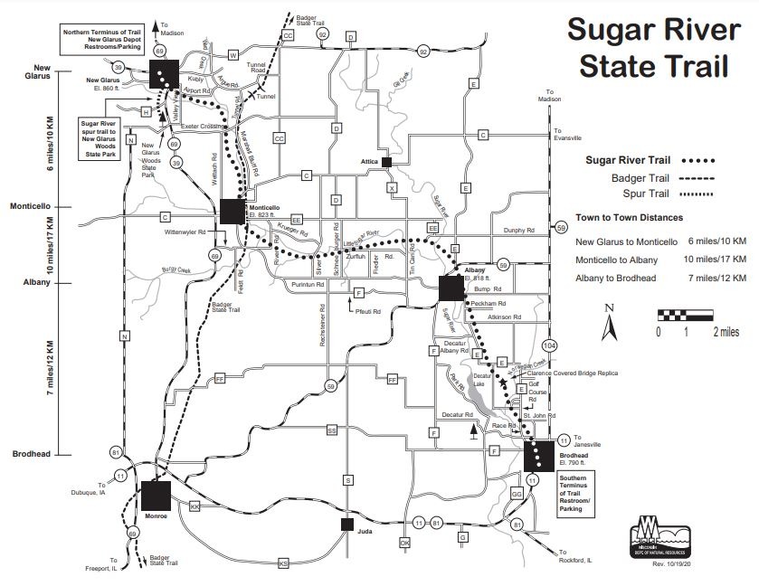
The Sugar River Trail is the closest state trail to Janesville. Brodhead is the Southern Terminus. In Brodhead, turn right from Hwy. 11 onto 10th Street to W. 3rd Ave. Then go left one block to the parking lot and restroom at the Trail Terminus near the adjacent historic Exchange Square. From Brodhead on the State Trail, you can bike over a replica of the Clarence Covered Bridge. The Albany to Monticello section through the Albany Wildlife Area is a rare and most beautiful natural area of our state. The SRST Head is located in New Glarus. This village is filled with great Swiss architecture and influence. Listen to the church bells and you can just imagine yourself in the Alps among the cows in the fields! The Sugar River State Trail is a great shaded ‘air conditioned’ and scenic trail for family biking! The entire length of the trail is 23 miles.
Our family has done this trail dozens of times, but the 46-mile round trip may be too much for the young ones, or those that don't ride often. I would recommend starting in Monticello or Albany and making New Glarus your destination. (See map below.) New Glarus is a wonderful town to walk through. It is filled with great Swiss architecture and influence. The shops are fun, restaurants great, and there is even a nice park in which to spend a lazy Sunday afternoon. Listen to the church bells and you can just imagine yourself in the Alps among the cows in the fields!
Bonus: City of Brodhead Pearl Island Trail:
The City of Brodhead has recently developed a biking/hiking trail from the spillway of the historic Mill Race on 11th St. to Decatur Dam. The trail may be accessed on 11th St., at Putnam Park, Decatur Road, or Headgates Park. The trail passes beautiful native prairie restorations, fishing areas, a floodplain forest and hiking trails that reach into the forest between the Mill Race and Sugar River. This 3 mile trail is ideal for a short family biking adventure.
A Prairie and Wildlife Corridor
Prairie remnants exist in many areas along the right-of-way. During the summer, a continual change in colorful prairie wildflowers and grasses can be seen. Lowland cattails and reeds are found in the wetlands; and woods with oaks, hickory, walnut, and cherry are interspersed between the dry prairies and other areas that have been invaded by sumac, willow and elderberry. The diverse vegetation contributes to a spectacular display of color in autumn.
Mammals found on the Sugar River Trail include deer, coyote, fox, bobcat, beaver, otter, woodchuck, skunk, mink, rabbit, fox and gray squirrels, chipmunk, ground squirrels, moles and shrews. Many kinds of snakes, turtles, salamanders are found along the trail as well. Almost every bird found in Wisconsin can be seen on the Sugar River Trail, more than 100 different species. The corridor totals 265 acres, but this provides more benefit to wildlife than a block of land the same size, because it gives access to more land along the trail and a variety of habitats.
A National Scenic and Recreational Trail
The Sugar River State Trail, from Bump Road to Exeter Crossing Road, is part of the Ice Age National Scenic Trail. The Ice Age Trail is a National Recreation Trail that, when completed, will travel over 1,000 miles of Wisconsin, along the terminal edge of the Wisconsin lobe of the last glacier to cover the state. More than 500 miles of the Ice Age Trail are open to the public now. The trail highlights the many topographic features that were created by the glaciers.
The National Park Service also has designated the Sugar River Trail as a national recreational trail.
For more information, ask:
Sugar River State Trail
418 Railroad St.
New Glarus WI 53574
(608) 527-2334 (summer), (608) 527-2335 (off season)
For a printable version of the map below, set your printer to high-quality printing,
and click here: Sugar River Trail Map